Understanding the massive M 7.7 Mentawai Earthquake

The Pulau Pagai Selatan, Sumatra earthquake of October 25, 2010 occurred as a result of thrust faulting on or near the subduction interface plate boundary between the Australia and Sunda plates.

At the location of this earthquake, the Australia Plate move north-northeast with respect to the Sunda plate at a velocity of approximately 57-69 mm/yr.
On the basis of the currently available fault mechanism information and earthquake depth it is likely that this earthquake occurred along the plate interface.
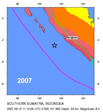
The subduction zone adjacent to the region of this event last slipped during the Mw 8.5 and 7.9 earthquakes of September 2007, and today’s event appears to have occurred near the rupture zones of those earthquakes.

Map Austrlia and Sunda plates - courtesy olehnielsen.dk

Today’s earthquake is the latest in a sequence of large ruptures along the Sunda megathrust, including :
– a M 9.1 earthquake that ruptured to within 800 km north of this earthquake in 2004;
– a M 8.6 700 km to the north between Nias and Simeulue in 2005;
– a M 7.5 300 km to the north near Padang in 2009.
– a Mw 8.7-8.9 rupture in 1797
– a Mw 8.9-9.1 earthquake in 1833
(text : courtesy USGS)


2010 Mentawai earthquake


2009 South Sumatra earthquake

2007 South Sumatra earthquake

2007 South Sumatra earthquake

2004 Sumatra - Andaman Islands - Banda Aceh earthquake

Overview page with all the articles we wrote on this dramatic earthquake / tsunami

Latest news page 4

Latest news page 3

Latest news page 2

Latest news page 1

Indonesia Tsunami – Australians surfers safe and well

Nine Australians and a Japanese man were in the area aboard surf charter boat MV Southern Cross when the quake struck.
Fears had been growing for the vessel, skippered by Australian Chris Scurrah and Japanese Akinori Fujita.

But the men finally made contact with their Padang-based company Sumatran Surfariis (Surfariis) on Tuesday night.
“They are now safe, they have been found,” staff member Yuli Rahmi told AAP.
“They only lost their phone signal, they didn’t even feel any tsunami.”
The men were now on land on the island of South Pagai
, Ms Rahmi said.

Earlier, humanitarian organisation SurfAid International had been coordinating a search for the vessel.

Read the full Nine News article from the Australian TV station

The story before

Nine Australians and a Japanese man who were believed to be aboard the Southern Cross were missing on Tuesday.
The missing group of surfers were on a traditional wooden boat, the Southern Cross, skippered by an Australian Chris Scurrah and Japanese Akinori Fujita.
SurfAid, a charity set up a decade ago to help villagers in the Mentawai region, said the boat was believed to be close to the quake’s epicentre.
Dave Jenkins, SurfAid’s founder, said Scurrah had “been around here for a long time. He knew to contact in if he could. So that’s why we’re extra concerned.”
A search and rescue mission for the Southern Cross had been launched, Jenkins said.
“We do have increasingly worrying reports of quite high numbers of people who are missing in villages,” he said, adding that he hopes to have accurate information on the missing boat by Wednesday.
Australia waited anxiously for news of its missing nationals.

The remote Mentawai islands are popular with surfers searching for big waves and pristine beaches.
Read the full Nine News Australia report here


Earthquakes list September 12, 2010

M 4.1      2010/09/12 20:09    Depth 5.0 km     WYOMING, USA
Feeble earthquake in Teton National Forest, 40 km from Jackson. This time in a slightly different area than a couple of weeks ago.

M 5.2      2010/09/12 16:35    Depth 36.8 km      MINDANAO, PHILIPPINES
Location of the epicenter has a big error margin. About 30 km out of the coast.

M 4.7      2010/09/12 14:41    Depth 58.2 km     KURIL ISLANDS
On top of the subduction area near the Kuril Kamchatka trench. Not dangerous

M 4.9      2010/09/12 13:01    Depth 27.9 km     EASTERN KAZAKHSTAN

Moderate earthquake in virgin like nature. Only nomads will have felt this earthquake.

M 5.0      2010/09/12 09:10    Depth 135.1 km     NEW BRITAIN REGION, PAPUA NEW GUINEA
Only 5 km from the beaches of Duke of York Island, and also close to the eastern shores of New Britain Island.  The area is a very complicated tectonic zone wit a lot of subduction zones. Earthquakes with this Magnitude are mostly harmless. The main dangers can come from local tsunamis generated by undersea landslides in the trenches which are clearly visible on this satellite picture

M 5.4      2010/09/12 07:40    Depth 48.9 km     ANDREANOF ISLANDS, ALEUTIAN IS., ALASKA
A very active earthquake area in a distant but beautiful area of Alaska. 50 km from Tanaga Volcano.

M 4.8      2010/09/12 07:05    Depth 34.6 km     SAMOA ISLANDS REGION
One of a number of earthquakes in the same subduction area. Nearest island : Niuatoputapu (Tonga). One of the villages on the island (Falehau) was extensively damaged by a tsunami after a M 8.0 earthquake struck the Samoan Islands area on September 29 2009. Panoramio picture of the shores of Falehau

M 5.3      2010/09/12 06:00    Depth 10.0 km     BALLENY ISLANDS REGION

Epicenter in the Southern Ocean. The 3th moderate earthquake in a couple of days in the same area

M 5.3      2010/09/12 06:00   Depth 10.1 km     SOUTH OF AUSTRALIA
In the Southern Sea, closer to Antarctica then to Australia and New Zealand

M 4.6      2010/09/12 05:25   Depth 199.8 km      NICARAGUA
Deep harmless earthquake on the shores of Lago de Nicaragua, 40 km from Rivas

seismograph - recordingUseful information to read this daily earthquake list
This earthquake list covers minor and major earthquakes in the world.
If a more detailed page is present, the earthquake line will be linked to the detailed page.
For your comfort, we will provide in most cases Google Satellite Map links to give you an idea where the earthquake struck, which terrain it happened and if villages or cities are located in the immediate vicinity. The reference for the time zone is UTC (Coordinated Universal Time, also called GMT)
The page is regularly updated to add new earthquakes.
green color = NOT dangerous for damage or injuries
orange color = MODERATE risk for damage or injuries
red color = CONSIDERABLE risk for damage or injuries

QuakeSOS has been developed to help actively people who are caught in an earthquake + delivers "Earthquake Report" information on your iPhoneQuakeSOS is a FREE iPhone application developed by Armand Vervaeck, the creator and main contributor to Earthquake Report. The Application simplifies immediate group communication to friends and family members (with your exact GPS location) and is constantly feeding the users with “Earthquake Report” news. Together with your own family and friends, QuakeSOS will be your closest earthquake friend.

Earthquakes list August 25, 2010

M 5.2      2010/08/25 22:57   Depth 10.0 km     TONGA
70 km out of the Tongo island of Eua (Eua National Park). A beautiful satellite view ofthe volcano arc and the ocean floor where one can clearly see that 1  tectonic plate is going underneath the other one (Pacific plate and Australian plate).

M 3.8      2010/08/25 17:20   Depth 4.9 km     CENTRAL CALIFORNIA, USA
Light earthquake at a short distance from Hearst Castle, a National Historic Landmark and known by many tourist. Click on the link for more details

M 5.1      2010/08/25 16:46   Depth 233.9 km     HALMAHERA, INDONESIA
Just on the northern tip of Pulau Morotai. Would be dangerous if shallow, but with a depth of 234 km it will be hardly felt.

M 4.6      2010/08/25 16:45   Depth 108.4 km     MINDANAO, PHILIPPINES
Light rather deep earthquake at least 70 km out of the coast

M 4.5   2010-08-25   13:51   Depth 10 km MOLUCCAS,  SERAM, INDONESIA
Shallow depth but not powerful enough to cause damage or injuries

M 5.0      2010/08/25 12:02   Depth 72.6 km CALAMA, ANTOFAGASTA, CHILE
Northern Chile is in constant motion this morning (local time).  This moderate quake, luckily rather deep at 72 km, occurred just 23 km to the South of Calama (population 143,084). We have given a preliminary color of orange because of the nearby city of Calama as the events took place only 15 minutes ago. If the Magnitude and depth numbers are confirmed, we will change our color coding to green.
Local newspaper El Mercurio de Calama just reported that people were frightened by the shock, but told also that NO disruption of the power took place.
Read also the testimonies in our Chile Facebook Page

Mina San JosèM 4.5      2010/08/25 11:36   Depth 35.1 km COPIAPO, ATACAMA,  CHILE
If the USGS location is adequate, the epicenter of this weak earthquake is only a couple of kilometers from the port of Caldera.
The epicenter of this earthquake was  only 60 km from San Jose Gold and Copper mine. The 33 (still alive) miners are surviving in a narrow space. It may take several months before the emergency teams can get the 33 miners out of their scary situation approx. 700 meters below the surface.
The authorities have reported that the rescue efforts are not hampered by this earthquake and that all actions are continuing as planned.
The area has regular powerful earthquakes, and additional concern for rescue teams. Read the article in La Nacion, Chile
Read also the testimonies in our Chile Facebook Page

M 4.8      2010/08/25 09:26   Depth 10.2 km OFF THE EAST COAST OF HONSHU, JAPAN
Just on the subduction fault line. Epicenter far enough away from the coast.

M 5.4      2010/08/25 08:55   Depth 40.5 km MOLUCCA SEA, INDONESIA
Moderate earthquake in the middle of the Molucca Sea. Not dangerous

M 5.3      2010/08/25 06:25   Depth 173.7 km MINAHASA, SULAWESI, INDONESIA
Epicenter near Bolaanguki – Not dangerous

M 5.0      2010/08/25 04:06   Depth 9.9 km WESTERN INDIAN-ANTARCTIC RIDGE
In the middle of the ocean in between Australia and Antarctica

M 4.8      2010/08/25 02:35   Depth 122.5 km TARAPACA, CHILE
Northern part of Chile with a deep hypocenter under the desert

M 4.1      2010/08/25 02:29   Depth 35.0 km OFFSHORE JALISCO, MEXICO
No Aftershock from yesterday’s Magnitude 6.1 earthquake but on the eastern edge of the North American plate

Useful information to read this daily earthquake list
This earthquake list covers minor and major earthquakes  in the world.
If a more detailed page is present, the earthquake line will be linked to the detailed page.
For your comfort, we will provide in most cases Google Satellite Map links to give you an idea where the earthquake struck, which terrain it happened and if villages or cities are located in the immediate vicinity. The reference for the time zone is UTC (Coordinated Universal Time)
The page is regularly updated to add new quakes.
green color = NOT dangerous for damage or injuries
orange color = MODERATE risk for damage or injuries
red color = CONSIDERABLE risk for damage or injuries

QuakeSOS has been developed to help actively people who are caught in an earthquake + delivers "Earthquake Report" information on your iPhoneQuakeSOS is a FREE  iPhone application developed by Armand Vervaeck, the creator and main contributor to Earthquake Report.  The Application simplifies immediate group communication to friends and family members (with your exact GPS location) and is constantly feeding the users with “Earthquake Report” news. Together with your own family and friends, QuakeSOS will be your closest earthquake friend.

Minor earthquakes are earthquakes without or with little damage risk.  In most cases these earthquakes have a Magnitude smaller than M 5.0 OR earthquakes with an hypocenter (depth) of more than 100 km OR earthquakes up to M 5.9 with an epicenter far away from populated areas.